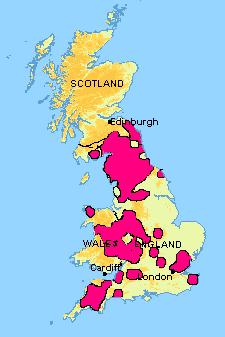
Map showing Infected Areas
Links to Maps of Infected Areas
*Essex, Kent and Suffolk
*Devon and Cornwall
*Wiltshire, Hampshire, North Berkshire and Swindon
*Cheshire, Derbyshire, Gloucestershire, Gwynedd, Herefordshire, Leicestershire, Monmouthshire, Powys, Shropshire, Staffordshire, Stoke on Trent, Warwickshire, West Midlands and Worcestershire
*Map of Infected Areas 7 and 26 - Anglesey
*Map of Infected Area 10 - Buckinghamshire and Northamptonshire
*Map of Infected Area 12 - Leicestershire, Lincolnshire, Nottinghamshire and Rutland
*Map of Infected Area 17 - Buckinghamshire, Milton Keynes, Northamptonshire and Oxfordshire
*Map of Infected Areas 2, 9, 14, 18 and 29 - Cumbria, Durham, Greater Manchester, Lancashire, Northumberland, North Yorkshire and Tyne and Wear
*Map of Infected Area 20 - Somerset
*Map of Infected Area 35 - Kent
*Map of Infected Area 87 - North Yorkshire
*Map of Infected Area 91 - Caerphilly, Rhondda, Merthyr Tydfil and Gwent
*Map of Scottish Infected Area. (Click here for high resolution version).